2.4 Station Coordinate System
Explains the original Cardassian external reference system based on the commandant's eyeline and korshin distance units, and describes the translated Starfleet three-axis Cartesian coordinate system added to the station's computers.
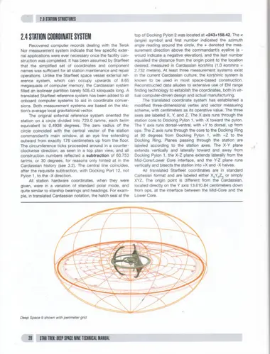
Recovered computer records dealing with the Terok Nor measurement system indicate that few specific external applications were ever necessary once the facility construction was completed. It has been assumed by Starfleet that the simplified set of coordinates and component names was sufficient for all station maintenance and repair operations. Unlike the Starfleet space vessel external reference system, which can occupy upwards of 8.65 megaquads of computer memory, the Cardassian system filled an isolinear partition barely 505.43 kiloquads long. A translated Starfleet reference system has been added to all onboard computer systems to aid in coordinate conversions. Both measurement systems are based on the station's average local gravitational vector.
The original external reference system oriented the station on a circle divided into 729.0 tarims, each tarim equivalent to 0.4938 degrees. The zero radius of the circle coincided with the central vector of the station commandant's main window, at an eye line extending outward from exactly 176 centimeters up from the floor. The circumference ticks proceeded around in a counterclockwise direction, as seen in a top plan view, and all construction numbers reflected a subtraction of 60.753 tarims, or 30 degrees, for reasons only hinted at in the Cardassian history (see 3.2). The central line coincides, after the requisite subtraction, with Docking Port 12, not Pylon 1, to the -X direction.
All station hardware coordinates, when they were given, were in a variation of standard polar mode, and quite similar to starship bearings and headings. For example, in translated Cardassian notation, the hatch seal at the top of Docking Pylon 2 was located at <243+158.42. The < = (angle) symbol and first number indicated the azimuth angle reading around the circle, the + denoted the measurement direction above the commandant's eyeline (a - would indicate a negative elevation), and the last number equalled the distance from the origin point to the location desired, measured in Cardassian korshins (1.0 korshins = 2.732 meters). At least three measurement systems exist in the current Cardassian culture; the korshinic system is known to be used in most space-based construction. Reconstructed data alludes to extensive use of EM range finding technology to establish the coordinates, both in virtual computer-driven design and actual manufacturing.
The translated coordinate system has established a modified three-dimensional vertex and vector measuring scheme, with centimeters as its operative value. The three axes are labeled X, Y, and Z. The X axis runs through the station core to Docking Pylon 1, with -X toward the pylon. The Y axis runs dorsal-ventral, with +Y to dorsal, up from ops. The Z axis runs through the core to the Docking Ring at 90 degrees from Docking Pylon 1, with +Z to the Docking Ring. Planes passing through the station are labeled according to the station axes. The X-Y plane extends vertically and laterally toward and away from Docking Pylon 1, the X-Z plane extends laterally from the Mid-Core/Lower Core interface, and the Y-Z plane runs vertically and bisects the station into +X and -X halves. All translated Starfleet coordinates are in standard Cartesian format and are labeled either X,Y,Z; or simply XYZ. The origin point is different from the Cardassian, located directly on the Y axis 13,610.84 centimeters down from ops, at the interface between the Mid-Core and the Lower Core.