2.3 The Grid System
The three-dimensional grid is defined by a central navigation beacon and two distant quasars, with Federation space divided into quadrants, octants, and sectors identified by a numbering scheme.
Inset #5 shows the arrangement of the axes and the resulting planes which form the three-dimensional grid system discussed in section 2.1. The origin of the grid system is defined by a central navigation beacon that transmits on both normal and subspace frequencies. To define the axes of the grid two very distant quasars are used as references. The extreme distances to the objects eliminates any parallax distortion in the orientation of the axis in the volume of space covered by the grid. Quasar 3C 294 provides the reference direction for the X-axis, 3C 68 the direction of the Z-axis, and the Y-axis is perpendicular to these axes at the origin. The X-axis takes on positive values toward the galactic center, and negative values toward its reference quasar (that is, away from the galactic center). Thereafter, normal geometric construction is followed, with the positive direction of the Y-axis at 90 degrees to the positive X-axis and the negative direction at 270 degrees. The Z-axis is positive in the direction of galactic north and negative in the opposite direction.
Federation space is divided into five major sections, as shown in inset #6: four quadrants, numbered 1 through 4, and a central sphere called Quadrant 0 (although not properly a quadrant at all). This sphere, 90 parsecs in radius and centered on the central navigation beacon, is surrounded on all sides by the four outer quadrants which, in turn, are bounded by the XZ and YZ planes. Although quadrant boundaries can be determined from the position of the central beacon and the two axis-defining quasars, a series of beacons have been installed to precisely mark these boundaries. The name quadrant, although historically correct, is now something of a misnomer, since the four outer quadrants are usually split up into northern and southern halves (as in inset #6) and are thus actually “octants.” By convention, the northern half of Quadrant 1 is called Quadrant 1 North, the southern half Quadrant 1 South, and so on. Inset #7 shows an exploded view of the Federation, clearly delineating the quadrant structure and the division into northern and southern halves.
Quadrants are further divided into sectors, as seen in inset #8, arranged in a concentric series of “shells” around the central sphere. The total volume of each sector is about 4,569 cubic parsecs. The volume of all sectors is kept approximately the same by adjusting the size of the defining angles and shell thickness. There are 1,500 sectors in each of the eight outer quadrants, and 668 sectors (arranged in a similar series of concentric shells) in Quadrant 0.
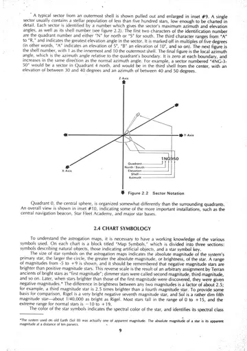
A typical sector from an outermost shell is shown pulled out and enlarged in inset #9. A single sector usually contains a stellar population of less than five hundred stars, low enough to be charted in detail. Each sector is identified by a number which gives the sector’s maximum azimuth and elevation angles, as well as its shell number (see figure 2.2). The first two characters of the identification number are the quadrant number and either “N” for north or “S” for south. The third character ranges from “A” to “R,” and indicates the greatest elevation angle in the sector. It is marked off in multiples of five degrees (in other words, “A” indicates an elevation of 5°, “B” an elevation of 10°, and so on). The next figure is the shell number, with 1 as the innermost and 10 the outermost shell. The final figure is the local azimuth angle, which is the azimuth angle relative to the quadrant’s boundary. It is zero at each boundary, and increases in the same direction as the normal azimuth angle. For example, a sector numbered “4NG-3-50” would be a sector in Quadrant 4 north, and would be in the third shell from the center, with an elevation of between 30 and 40 degrees and an azimuth of between 40 and 50 degrees.
Quadrant 0, the central sphere, is organized somewhat differently than the surrounding quadrants. An overall view is shown in inset #10, indicating some of the more important installations, such as the central navigation beacon, Star Fleet Academy, and major star bases.