System Access Reference
Systems Nominal
FEDERATION CARTOGRAPHY & NAVIGATION
STARDATE -255192.3 --:--:--
Star Trek Maps · Chapter 7 · Chart A — United Federation of Planets

7.0 Astrogation Map #1 — The Federation in the XY Plane

Chart A presents Astrogation Map #1, a top-down view of the United Federation of Planets projected onto the XY plane, accompanied by side insets showing the Milky Way and the grid system, a general description and statistics of the Federation, a starship patrol regions table, the map key, and the chart credits.
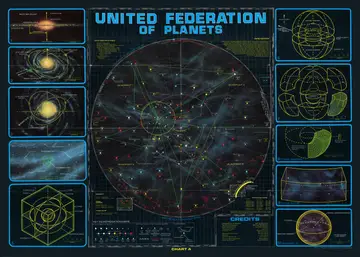
Astrogation Map #1 — the central illustration of Chart A: an overall view of the United Federation of Planets from the direction of galactic north, with the stars projected onto the XY plane, showing inhabited star systems, the four quadrants, major space lanes, star bases and the bordering empires, overlaid with a ten-parsec reference grid and a radial gridwork.
Inset #1: edge-on view of the Milky Way Galaxy, with Federation Space marked roughly 9,200 parsecs from the galactic center, pointers toward quasar 3C 68 (galactic north) and quasar 3C 294, and the galactic north/south poles indicated.
1 Inset #1: edge-on view of the Milky Way Galaxy, with Federation Space marked roughly 9,200 parsecs from the galactic center, pointers toward quasar 3C 68 (galactic north) and quasar 3C 294, and the galactic north/south poles indicated.
Inset #2: the galaxy tilted about 45 degrees to a near top view, showing the spiral arms, the position of Federation Space and the nearer globular clusters NGC 1875 and M 13, with the quasar references.
2 Inset #2: the galaxy tilted about 45 degrees to a near top view, showing the spiral arms, the position of Federation Space and the nearer globular clusters NGC 1875 and M 13, with the quasar references.
Inset #3: the galaxy tilted further to a full top view looking down from galactic north, showing the overall spiral-arm structure with globular clusters NGC 1875 and M 13.
3 Inset #3: the galaxy tilted further to a full top view looking down from galactic north, showing the overall spiral-arm structure with globular clusters NGC 1875 and M 13.
Inset #4: an enlargement of the region explored by the UFP, a section of the Carina-Cygnus arm near the Orion spur with parts of the neighboring Sagittarius and Perseus arms; the small cube near the center denotes Federation Space, with a parsecs (x 100) scale.
4 Inset #4: an enlargement of the region explored by the UFP, a section of the Carina-Cygnus arm near the Orion spur with parts of the neighboring Sagittarius and Perseus arms; the small cube near the center denotes Federation Space, with a parsecs (x 100) scale.
Grid-system insets: diagrams of the three-dimensional grid sphere (Northern and Southern Hemispheres divided along the X-Y plane), the exploded view of the Federation showing the quadrant structure and division into octants, the concentric series of sector shells, a typical sector, and Quadrant 0 (the central sphere; Diameter = 180 parsecs, Volume = 3,053,628 cubic parsecs) with its major installations.
Key to Astrogation Maps: the map symbols legend, divided into Stars and Natural Objects (absolute magnitude and spectral class scales; nova, pulsar and black hole; binary, trinary and variable stars; nebula), Artificial Objects, Tracks and Boundaries (star base, deep space station, communication relay, outpost, buoy, major space lanes, starship patrol, communication lanes, danger area, Federation Space, Quadrant 0), and the Star Symbols key.

General Description

On May 8, 2127, the United Federation of Planets was formed as a loose political alliance of five star systems, encompassing a spherical territory 90 parsecs in diameter (roughly 380,000 cubic parsecs) centered on Sol. With the advent of the time-warp star drive in 2161 and the accession of Rigel in 2166, the Federation was redefined to include its present territories; the center, by interstellar agreement, became a point on the galactic plane equidistant between planar projections of Rigel, Deneb and Antares. Currently, the border of the Federation is disputed by several other political units, including the Klingon Empire, Tholian Assembly, and Gorn Hegemony. The Federation also contains within its volume a number of unfriendly star systems, such as the Kzinti Patriarchy and the Melkotians, as well as a number of independent star systems, both human and non-human.

United Federation of Planets

  • Diameter = 480 parsecs
  • Volume = 57,905,836 cubic parsecs
  • Average Star Density = 0.097 stars per cubic parsec
  • Total Star Population = 5,629,000
  • Number of Inhabited Star Systems = 1,355
    • Number of Member Star Systems = 29
    • Number of Affiliated Star Systems = 771
    • Number of Independent or Neutral Star Systems = 544
    • Number of Hostile Star Systems = 11
  • Total Sentient Population (2260 census) = 71.8 billion

Starship Patrol Regions

  • Quadrant 0 — U.S.S. Potemkin NCC-1702
  • Quadrant 1 North — U.S.S. Intrepid NCC-1631
  • Quadrant 2 North — U.S.S. Valiant NCC-1623
  • Quadrant 3 North — U.S.S. Exeter NCC-1672
  • Quadrant 4 North — U.S.S. Yorktown NCC-1717
  • Quadrant 1 South — U.S.S. Farragut NCC-1647
  • Quadrant 2 South — U.S.S. Constellation NCC-1017
  • Quadrant 3 South — U.S.S. Enterprise NCC-1701
  • Quadrant 4 South — U.S.S. Defiant NCC-1764

Four Starships — Constitution (NCC-1700), Excalibur (NCC-1664), Hood (NCC-1703) and Lexington (NCC-1709) — have been given military or defense assignments. Republic (NCC-1371) is currently used as a cadet training vessel.

Credits

  • Design & Co-ordination — Jeffrey Maynard
  • Technical Direction — Michael McMaster
  • Astronomical Art — Geoffrey Mandel
  • Technical Graphics — Lee Cole
  • Air Brush Art — Michael Nicastre, Rick Sternbach
  • Mechanical Production — Barbara White
  • Manual — John Upton
  • Technical Assistance — Sara Hillman
  • From an idea suggested by Rena Wolner
  • Editor for Bantam — Sydny Weinberg
An unhandled error has occurred. Reload 🗙

Rejoining the server...

Rejoin failed... trying again in seconds.

Failed to rejoin.
Please retry or reload the page.

The session has been paused by the server.

Failed to resume the session.
Please retry or reload the page.