System Access Reference
Systems Nominal
FEDERATION CARTOGRAPHY & NAVIGATION
STARDATE -255192.3 --:--:--
Star Trek Maps · Visual Records

Technical Schematics

55 figures and diagrams. Select any plate to enlarge.

Figures
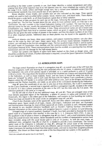
Astrogation map #1 reference detail and Map Symbols block as printed on chart A (overview of the UFP projected onto the XY plane).
Appendix title plate: "APPENDIX — Star System Data."
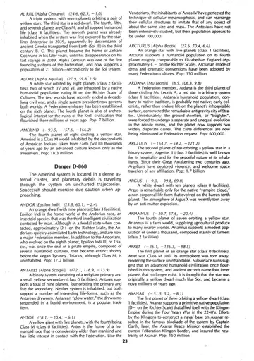
Two-column alphabetical star-system catalog, Adhara through Camus, with interspersed Warning, Danger, and cross-reference notices.
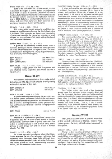
Two-column alphabetical star-system catalog, Canopus through 40 Eridani, with Warning and Prohibited notices and cross-references.
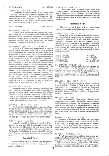
Two-column alphabetical star-system catalog, the Vulcan world of 40 Eridani through Kalandan Outpost, with Danger and Prohibited notices.
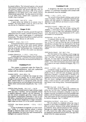
Two-column alphabetical star-system catalog, I-370 through Memory Alpha, with Prohibited notices and cross-references.
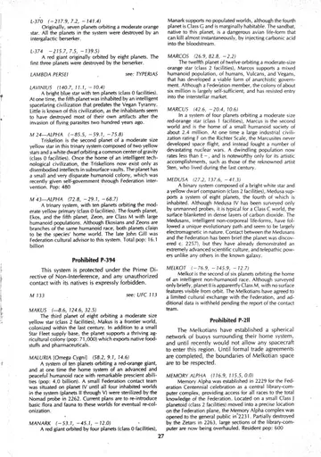
Two-column alphabetical star-system catalog, Menkalina through Organia, with Danger, Warning, and Prohibited notices and cross-references.
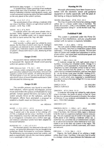
Two-column alphabetical star-system catalog, the conclusion of Organia through Sherman's Planet, including the extended Rigel and Romulan entries and a Danger notice.
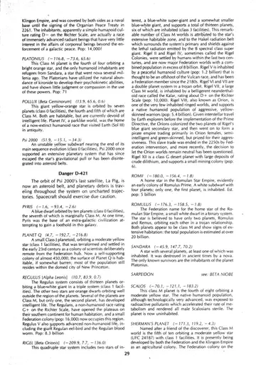
Two-column alphabetical star-system catalog, the conclusion of Sherman's Planet through Time Planet, with Prohibited notices and cross-references.
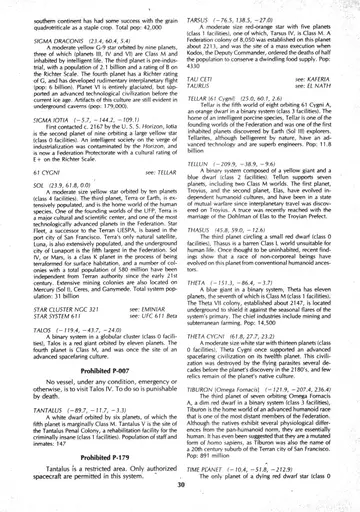
Two-column alphabetical star-system catalog, the conclusion of Time Planet through UFC 892, with Prohibited notices and cross-references.
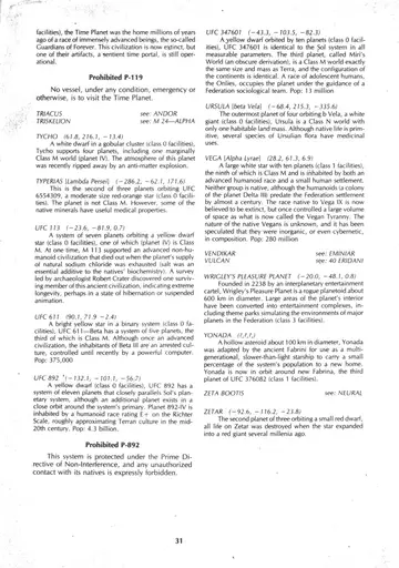
Two-column alphabetical star-system catalog, the final entries UFC 347601 through Zetar, completing the appendix.
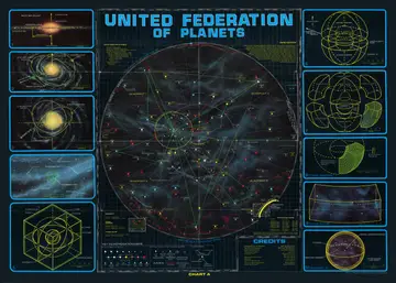
Astrogation Map #1 — the central illustration of Chart A: an overall view of the United Federation of Planets from the direction of galactic north, with the stars projected onto the XY plane, showing inhabited star systems, the four quadrants, major space lanes, star bases and the bordering empires, overlaid with a ten-parsec reference grid and a radial gridwork.
Grid-system insets: diagrams of the three-dimensional grid sphere (Northern and Southern Hemispheres divided along the X-Y plane), the exploded view of the Federation showing the quadrant structure and division into octants, the concentric series of sector shells, a typical sector, and Quadrant 0 (the central sphere; Diameter = 180 parsecs, Volume = 3,053,628 cubic parsecs) with its major installations.
Key to Astrogation Maps: the map symbols legend, divided into Stars and Natural Objects (absolute magnitude and spectral class scales; nova, pulsar and black hole; binary, trinary and variable stars; nebula), Artificial Objects, Tracks and Boundaries (star base, deep space station, communication relay, outpost, buoy, major space lanes, starship patrol, communication lanes, danger area, Federation Space, Quadrant 0), and the Star Symbols key.
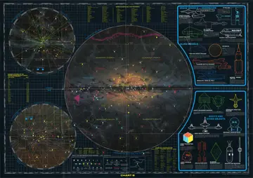
Chart B — full plate. Astrogation Map Two: a side-view (X-Z plane) galactic cross-section of the United Federation of Planets, surrounded by inset maps, member-system roster, reference tables, and illustrated catalogues of spacecraft and buoys.
Astrogation Map Two — central galactic cross-section ("Federation Side View"), showing the Energy Barrier across the galactic rim, the bright galactic core, the four quadrants (Quadrant 3 North, Quadrant 4 North, Quadrant 3 South, Quadrant 4 South), and labelled areas of contact with the Klingon Empire, the Romulan Star Empire and the Tholian Assembly, with the path of the U.S.S. Enterprise traced through Federation space.
Upper-left inset — Astrogation Map Three, Top View (inset map from Chart A) of the Sol region and the Kzinti Patriarchy, with star systems and connecting lanes.
Lower-left inset — Astrogation Map Four, Side View of the Sol region, showing the original boundaries of the Federation in the X-Y and X-Z planes.
Named Planets and Their Primaries — reference table running across the top of the plate, listing named planets alongside their primary stars.
Member Systems of the United Federation of Planets — roster of member star systems listed in order of admittance, with year of admission.
Space Vessels — Federation: illustrated profiles of the Constitution Class Starship (U.S.S. Enterprise, NCC-1701), the Space Cruiser (S.S. Aurora, NCC-C1200), the DY Class Sleeper Ship (Woden / DY-504), the Starliner (UESP Enterprise), and the Class F Shuttlecraft (NCC-1701/2, Columbus).
Alien Vessels: illustrated profiles of the Tholian Space Cruiser, the Klingon "Klolode" Class Battle Cruiser, and the First Federation flagship Fesarius (with its spherical hull).
Buoys and Other Objects: illustrated catalogue of the Ship's Recorder-Marker, Approach Position Beacon (Sol-4), Deep Space Station (K-Class), Regional Marker Buoy (G-5), First Federation Buoy, Kzinti Marker Buoy, Melkotian Buoy, Klingon Marker Buoy, and Navigation Beacons (lane marker XL-397 and danger beacon D-631).
Key to Astrogation Maps — legend identifying star symbols, natural objects, artificial objects, tracks and boundaries, together with the Spectral Class and Planetary Classification reference tables; labelled "Astrogation Map Two — X-Z Plane."
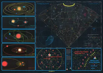
Chart C — full plate, combining the column of illustrated star-system insets, Astrogation Map Five (Quadrant 3 South, XY plane), the inset maps of the Klingon Empire and the Romulan Star Empire and Neutral Zone, and the Key to Astrogation Maps.
Astrogation Map Five — central top-down (XY plane) view of Quadrant 3 South, the Enterprise's zone of patrol, showing the Boundary of Federation, the First Federation, the orbit of a comet, communications lanes, outpost colonies, the marker beacon and buoy boundaries, the path of a Romulan vessel, and named star systems and worlds such as Tiburon, Mandel's Star, Omega Fornacis, Fabrina, Lactra, Delta Theta, Minara, Ringworld, Daran, Halka, Triskelion, Suligowski's Star, Winston's Star, Cole's Star, Argelius, Tantalus, the sites of the lost U.S.S. Horizon and the lost Beagle, and the Romulan Neutral Zone.
Sol system inset — orbital diagram of the Sol system showing the yellow primary, the four inner terrestrial planets and the outer gas giants, with the Class M worlds Terra and Mars.
Triskelion inset — orbital diagram of the M 24 trinary star system, showing the primary M 24-Alpha with its two planets and the secondary star with its single Class M planet, Triskelion.
Talos inset — orbital diagram of the Talos star group, showing the surviving red giant and its five inner planets in highly eccentric orbits.
Deneb inset — orbital diagram of the Deneban system, showing the primary, its four Class M worlds (II through V) and the dim red dwarf companion in a wide outer orbit.
Gamma Vertis inset — orbital diagram of the Gamma Vertis system, showing the large gas giant ("failed star") and its planets, including the single Class M world.
Klingon Empire inset map — chart of the inner star systems of the Klingon Empire, centered on the home planet Kazh and its ring of eight battle stations (1 through 8), with named worlds including Krell, Korreg, Kura, Kapella Minor, Korvus, Kumar, Klamath, Kantru, Kanoru, Graf, Tonan and Kanthat, and a light-years scale.
Romulan Star Empire inset map — chart of Earth Outpost Sector Z-6 showing the Romulan Neutral Zone arc, the line of Federation asteroid outposts (1 through 8), the Romulan Star Empire, and the home worlds Romulus and Romii, with a light-years scale.
Relative Locations diagram — small schematic showing the relative positions of the United Federation of Planets, the Klingon Empire and the Romulan Star Empire.
Galactic plane orientation diagram — wireframe "view down" cutaway showing the section of the galactic disc covered by the chart and its XYZ axes.
Key to Astrogation Maps — legend for Stars and Natural Objects (absolute magnitude and spectral class scales; nova, pulsar, neutron star, black hole, planetoid, nebula, binary, trinary and variable stars) and for Artificial Objects, Tracks and Boundaries (outpost, buoy, star, deep space communication, base station relay, major space lanes, starship patrol routes, communication lanes, federation member territory, foreign boundaries, danger areas, danger-do-not-cross, and tracks of notable objects, blue incoming and red outgoing), together with the Star Symbols key.
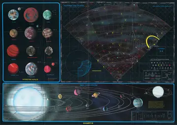
Chart D — full plate, combining the "Interesting Worlds" gallery, Astrogation Map Six (Quadrant 3 South, X-Z plane), the Key to Astrogation Maps, and the Rigel Star System cutaway.
Interesting Worlds — a panel of full-color astronomical plates depicting notable planets of the quadrant, including Earth, Vulcan, Argo and other worlds, each labelled with its name.
Astrogation Map Six — central side view (X-Z plane) of Quadrant 3 South, the U.S.S. Enterprise's zone of patrol, showing the boundary of Federation territory, the Enterprise zone of patrol, the radial sector gridwork, and named star systems and worlds such as Feinberg's Star, Argelius, Epsilon, Babel, Vulcan, Excalbia, Omicron Delta, Lactra, Delta Theta, Arellost, the site of the lost U.S.S. Horizon, the Romulan Empire and Romulan Neutral Zone, Fabrina, Organia, Triskelion, the Tantalus colony, Sherman's Planet, Yonada, Ardana, the Melkotian space, UFC 347601, Wise's Star, Simmons' World, and the marker beacon and buoy boundaries.
Key to Astrogation Maps — legend for Stars and Natural Objects (absolute magnitude and spectral class scales; nova, pulsar, neutron star, black hole, planetoid, nebula, binary, trinary and variable stars) and for Artificial Objects, Tracks and Boundaries (outpost, buoy, star, deep space communication, major space lanes, starship patrol routes, communication lanes, federation member territory, foreign boundaries, danger areas, and tracks of notable objects, blue incoming and red outgoing), together with the Star Symbols key.
Rigel Star System — cutaway diagram of the Rigel (Beta Orionis) system showing the primary star Rigel A, its binary companion Rigel B, and the orbits of the numbered planets Rigel I through Rigel XII (including the Class M worlds II, IV, V, VII and VIII / Orion), with a distance-from-primary scale.

1 · Introduction

Inset #1: edge-on view of the Milky Way Galaxy, with Federation Space marked roughly 9,200 parsecs from the galactic center, pointers toward quasar 3C 68 (galactic north) and quasar 3C 294, and the galactic north/south poles indicated.
1 Inset #1: edge-on view of the Milky Way Galaxy, with Federation Space marked roughly 9,200 parsecs from the galactic center, pointers toward quasar 3C 68 (galactic north) and quasar 3C 294, and the galactic north/south poles indicated.
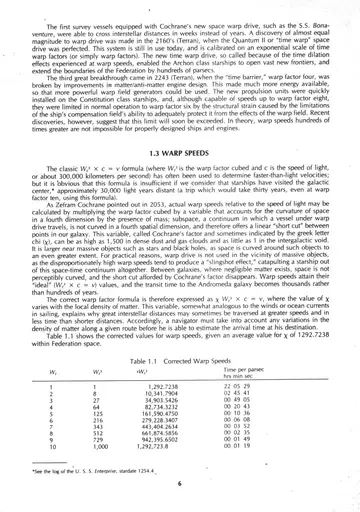
Table 1.1 Corrected Warp Speeds: warp factor, warp factor cubed, corrected warp speed (using an average Cochrane's factor of 1292.7238 within Federation space), and time per parsec for warp factors 1 through 10.
1.1 Table 1.1 Corrected Warp Speeds: warp factor, warp factor cubed, corrected warp speed (using an average Cochrane's factor of 1292.7238 within Federation space), and time per parsec for warp factors 1 through 10.

2 · The Charts

Inset #2: the galaxy tilted about 45 degrees to a near top view, showing the spiral arms, the position of Federation Space and the nearer globular clusters NGC 1875 and M 13, with the quasar references.
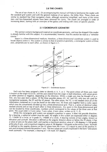
2 Inset #2: the galaxy tilted about 45 degrees to a near top view, showing the spiral arms, the position of Federation Space and the nearer globular clusters NGC 1875 and M 13, with the quasar references.
Coordinate System
2.1 Coordinate System
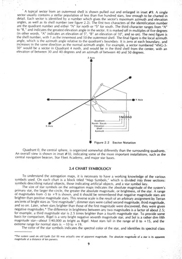
Sector Notation
2.2 Sector Notation

3 · Navigation

Inset #3: the galaxy tilted further to a full top view looking down from galactic north, showing the overall spiral-arm structure with globular clusters NGC 1875 and M 13.
3 Inset #3: the galaxy tilted further to a full top view looking down from galactic north, showing the overall spiral-arm structure with globular clusters NGC 1875 and M 13.
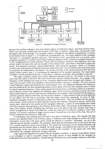
Figure 3.1 Navigation Computer System — block diagram showing the computer subsystem (central processing unit, memory bank, input/output controller) linked to peripheral devices and to the helm controls and central computer, with broken lines indicating the expanded equipment used on larger ships.
3.1 Figure 3.1 Navigation Computer System — block diagram showing the computer subsystem (central processing unit, memory bank, input/output controller) linked to peripheral devices and to the helm controls and central computer, with broken lines indicating the expanded equipment used on larger ships.
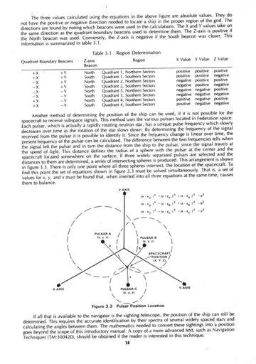
Table 3.1 Region Determination — table relating the closer quadrant boundary beacons and the north or south beacon to the resulting region and the signs of its X, Y, and Z values.
3.1 Table 3.1 Region Determination — table relating the closer quadrant boundary beacons and the north or south beacon to the resulting region and the signs of its X, Y, and Z values.
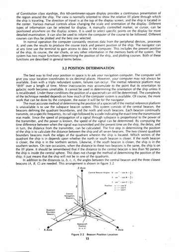
Figure 3.2 Beacon Position Location — three-dimensional coordinate diagram illustrating how beacon-to-ship distances locate a vessel within the grid.
3.2 Figure 3.2 Beacon Position Location — three-dimensional coordinate diagram illustrating how beacon-to-ship distances locate a vessel within the grid.
Figure 3.3 Pulsar Position Location — three-dimensional coordinate diagram showing position fixing from pulsar references.
3.3 Figure 3.3 Pulsar Position Location — three-dimensional coordinate diagram showing position fixing from pulsar references.
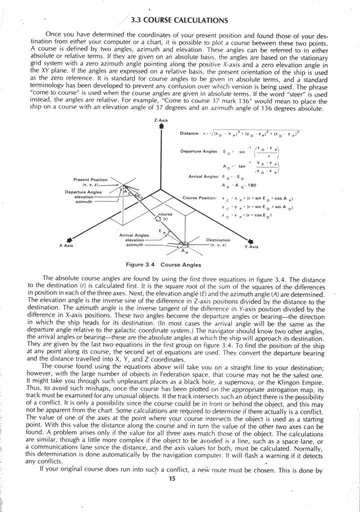
Figure 3.4 Course Plotting — three-dimensional vector diagram showing present position, destination, and the distance and bearing angles between them.
3.4 Figure 3.4 Course Plotting — three-dimensional vector diagram showing present position, destination, and the distance and bearing angles between them.
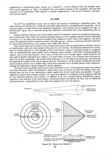
Figure 3.5 Space Lane Segment — cross-section diagram of a space lane segment showing its structure and the data identifying it.
3.5 Figure 3.5 Space Lane Segment — cross-section diagram of a space lane segment showing its structure and the data identifying it.
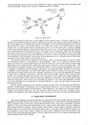
Figure 3.6 Space Lanes — diagram of intersecting space lanes with ship symbols illustrating traffic flow along the lanes.
3.6 Figure 3.6 Space Lanes — diagram of intersecting space lanes with ship symbols illustrating traffic flow along the lanes.

4 · Regulations

Inset #4: an enlargement of the region explored by the UFP, a section of the Carina-Cygnus arm near the Orion spur with parts of the neighboring Sagittarius and Perseus arms; the small cube near the center denotes Federation Space, with a parsecs (x 100) scale.
4 Inset #4: an enlargement of the region explored by the UFP, a section of the Carina-Cygnus arm near the Orion spur with parts of the neighboring Sagittarius and Perseus arms; the small cube near the center denotes Federation Space, with a parsecs (x 100) scale.
An unhandled error has occurred. Reload 🗙

Rejoining the server...

Rejoin failed... trying again in seconds.

Failed to rejoin.
Please retry or reload the page.

The session has been paused by the server.

Failed to resume the session.
Please retry or reload the page.