System Access Reference
Systems Nominal
THE COMPLETE ATLAS OF STAR TREK
STARDATE -255192.3 --:--:--
Star Charts · Visual Records

Technical Schematics

125 figures and diagrams. Select any plate to enlarge.

Figures
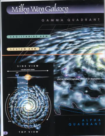
Title spread for the Milky Way Galaxy chapter, showing a top view of the spiral galaxy with the Sagittarius and Scutum arms labeled, an inset side view across 100,000 light-years, and an inset top view, between the Gamma and Alpha Quadrants.
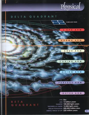
Top view of the Milky Way with its spiral arms labeled from the core outward: 3 KPC Arm, Norma Arm, Crux Arm, Carina Arm, Orion Arm, Perseus Arm, and Outer Arm, between the Delta and Beta Quadrants, with the galactic statistics panel.
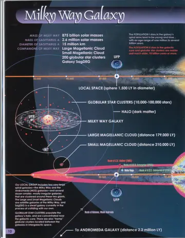
Side and top views of the Milky Way showing Local Space (a sphere 1,500 LY in diameter), globular star clusters, the dark-matter halo, the Large Magellanic Cloud (distance 179,000 LY), the Small Magellanic Cloud (distance 210,000 LY), and an arrow toward the Andromeda Galaxy (distance 2.2 million LY); marked with the routes of the S.S. Valiant (2065) and U.S.S. Enterprise.
Side view of the galactic disk, labeling the halo (dark matter), the spiral arms (Population I stars), and the galactic core (Population II stars), with a scale of distance in light-years.
Cross-section view of the galaxy labeling Sagittarius A (massive black hole), the Great Barrier, and the Galactic Barrier, with a scale in light-years.
Detail diagram of the toroidal Galactic Barrier and the spherical Great Barrier surrounding the galactic core, with arrows indicating the barriers around the disk.
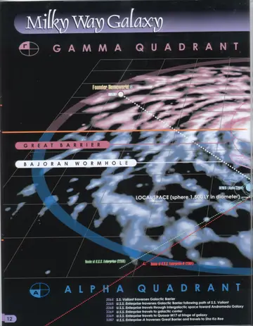
Map of the galaxy along the Alpha/Gamma boundary showing the Great Barrier, the Bajoran Wormhole, the Founder Homeworld and Ibran, Deneb (Alpha Cygni), Local Space, and the routes of the U.S.S. Enterprise (2268) and Enterprise-D (2364).
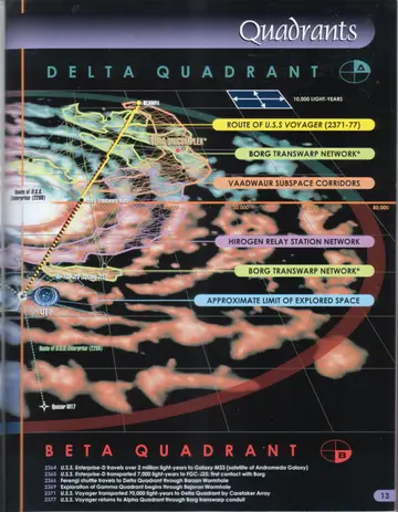
Delta/Beta Quadrant map showing the route of the U.S.S. Voyager (2371-77), the Borg transwarp network, Vaadwaur subspace corridors, the Hirogen relay station network, the approximate limit of explored space, the Borg Unicomplex, and Quasar M17.
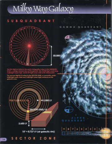
Sector Zone diagram showing the subquadrant wheel (lettered and numbered wedges) and the concentric sector-zone rings, with a top view of the galaxy and an isometric sector grid (sector grid 15) scaled at 5,000 LY by 3,600 LY.
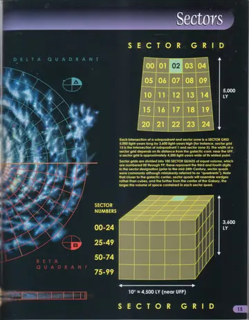
Sector Grid diagram showing a 5x5 array of numbered sector quads (00-24) measuring 5,000 LY, and an isometric cube illustrating sector numbers 00-24, 25-49, 50-74, and 75-99 at roughly 4,500 LY (near UFP) by 3,600 LY.
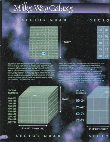
Sector Quad diagram showing the 10x10 grid of numbered sector blocks (1,000 LY across), an isometric sector-quad cube at roughly 900 LY (near UFP) by 800 LY, and a sector-block grid keyed to sector numbers 00-24 through 75-99 at about 100 LY.
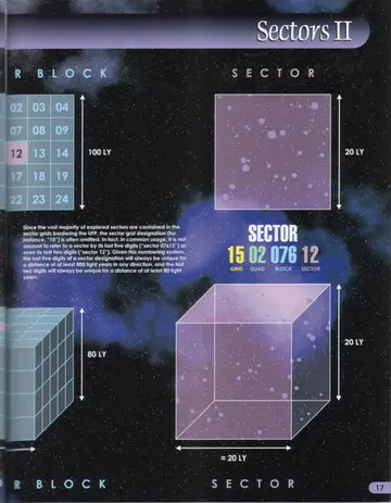
Sector Block diagram showing the 5x5 array of numbered sectors within a block (100 LY, 80 LY) and an isometric block cube.
Sector diagram illustrating a single 20-LY sector as a star-filled square and cube, with a worked example of a full sector designation: 15 (Grid) 02 (Quad) 076 (Block) 12 (Sector).
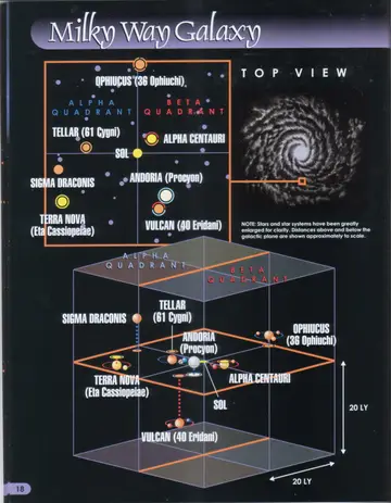
Top view of the eight sectors nearest Sol, plotting Ophiucus (36 Ophiuchi), Tellar (61 Cygni), Sigma Draconis, Terra Nova (Eta Cassiopeiae), Sol, Alpha Centauri, Andoria (Procyon), and Vulcan (40 Eridani) across the Alpha/Beta Quadrant border, with an inset locating the region within the galaxy. Note: stars and star systems have been greatly enlarged for clarity; distances above and below the galactic plane are shown approximately to scale.
Cross-section (side) view through the Alpha/Beta Quadrant border showing the same eight nearby star systems—Sigma Draconis, Tellar (61 Cygni), Andoria (Procyon), Ophiucus (36 Ophiuchi), Terra Nova (Eta Cassiopeiae), Sol, Alpha Centauri, and Vulcan (40 Eridani)—positioned above and below the galactic plane within a 20-LY cube.
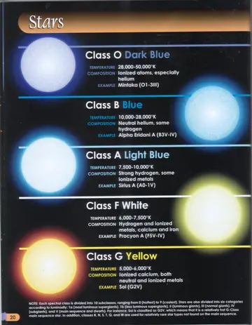
Illustrated comparison of stellar spectral classes O, B, A, F and G, each shown as a glowing star coloured by class with temperature, composition and an example star.
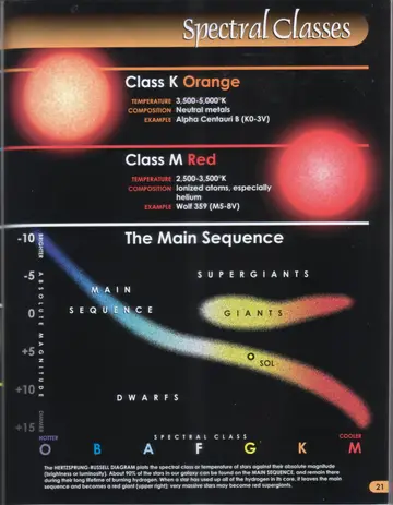
Illustrated comparison of stellar spectral classes K and M, each shown as a glowing star coloured by class with temperature, composition and an example star.
The Hertzsprung-Russell diagram, plotting absolute magnitude (brighter at top, dimmer at bottom) against spectral class O, B, A, F, G, K, M (hotter at left, cooler at right), showing the main sequence, dwarfs, giants and supergiants, with Sol marked on the main sequence.
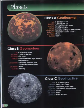
Class A Geothermal planet, a partially molten orange-red world.
Class B Geomorteus planet, a dark cratered world resembling Mercury.
Class C Geoinactive planet, a frozen grey cratered world.
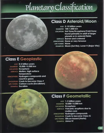
Class D Asteroid/Moon, a barren cratered grey body resembling Earth's Moon.
Class E Geoplastic planet, a molten tan-and-red world.
Class F Geometallic planet, a green volcanic world.
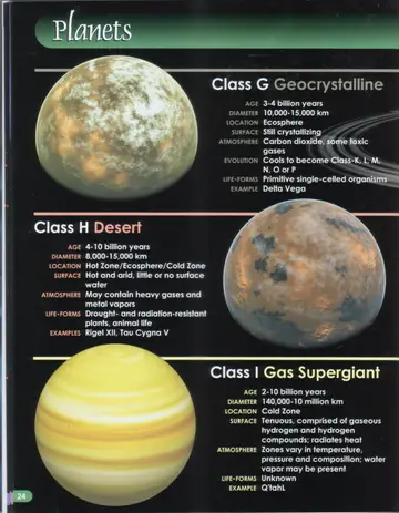
Class G Geocrystalline planet, a pale tan crystallizing world.
Class H Desert planet, a hot arid world with mottled brown and grey terrain.
Class I Gas Supergiant, a banded yellow gas world.
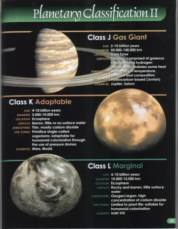
Class J Gas Giant, a banded ringed gas world resembling Jupiter.
Class K Adaptable planet, a barren reddish-tan world resembling Mars.
Class L Marginal planet, a rocky greenish-grey world.
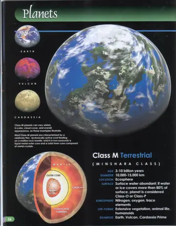
A large blue-and-white Class M planet resembling Earth, shown with clouds, oceans and continents.
Comparative Class M examples labelled Earth, Vulcan and Cardassia, illustrating the wide variation in colour and appearance.
Cutaway diagram of a Class M planet's interior, showing the crust, mantle, outer core, inner core and convection currents.
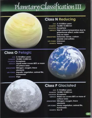
Class N Reducing planet, a dense pale-yellow greenhouse world resembling Venus.
Class O Pelagic planet, a blue ocean world with white clouds.
Class P Glaciated planet, a white ice-covered world.
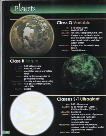
Class Q Variable planet, a mottled green-and-grey world with patchy water and ice.
Class R Rogue planet, a dark green world with swirling cloud patterns.
Classes S-T Ultragiant, a vast pale gaseous world.
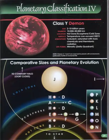
Class Y Demon planet, a turbulent red world saturated with toxic chemicals.
Comparative Sizes and Planetary Evolution diagram: planetary classes arranged by size around a central star (Class J) across the cold zone, ecosphere and hot zone, with evolution arrows (A to C; E to F to G) and a key showing classes P, K, L, M, O and N, extending to the cometary halo (Oort cloud).
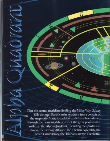
Familiar landmarks of the Alpha Quadrant seen from an unfamiliar perspective: the San Francisco region on Earth (including Starfleet Headquarters and Starfleet Academy), shown on a Cardassian tactical map intercepted by allied forces shortly after the Breen attack on Earth in 2375.
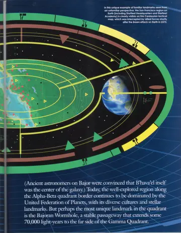
Continuation of the Cardassian tactical map, showing Earth and surrounding orbital rings against the stars.
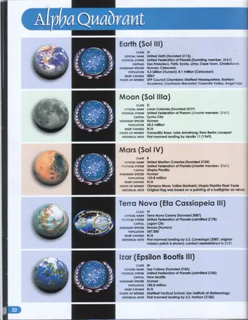
Planetary portraits and emblems for Earth, the Moon, Mars, Terra Nova, and Izar.
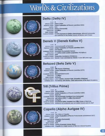
Planetary portraits and emblems for Delta, Deneb V, Betazed, Trill, and Capella.
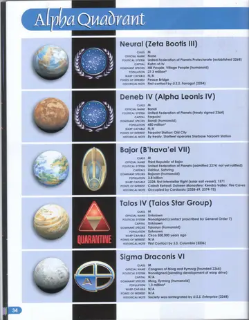
Planetary portraits and emblems for Neural, Deneb IV, Bajor, Talos IV (with QUARANTINE warning), and Sigma Draconis VI.
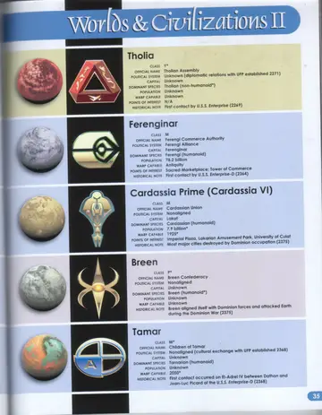
Worlds & Civilizations II: planetary portraits and emblems for Tholia, Ferenginar, Cardassia Prime, Breen, and Tamar.
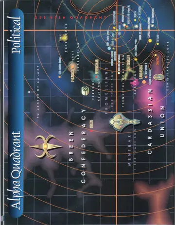
Political map of the Alpha Quadrant (left page): the Breen Confederacy, Ferengi Alliance, Promellians, Tzenkethi Coalition, and Cardassian Union, with the Demilitarized Zone and the direction toward the center of the galaxy.
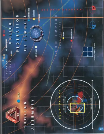
Political map of the Alpha Quadrant (right page): the United Federation of Planets, Talarian Republic, Tholian Assembly, and the bordering Tkon Empire region, with a locator map and one-sector grid scale.
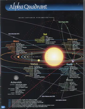
Chart of the Sol system showing the Sun and inner planets (Mercury, Venus, Earth, Moon, Mars), the asteroid belt, the Mars Defense Perimeter, and the routes of the Borg cube (2372) and the Phoenix (2063).
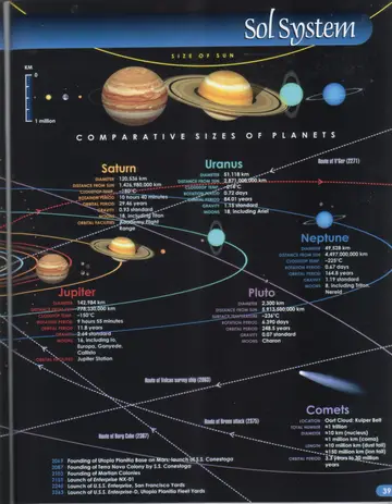
Comparative sizes of the planets and the outer Sol system (Jupiter, Saturn, Uranus, Neptune, Pluto) with comets, the size of the Sun, and the routes of V'Ger (2271), the Vulcan survey ship (2063), and the Breen attack (2375).
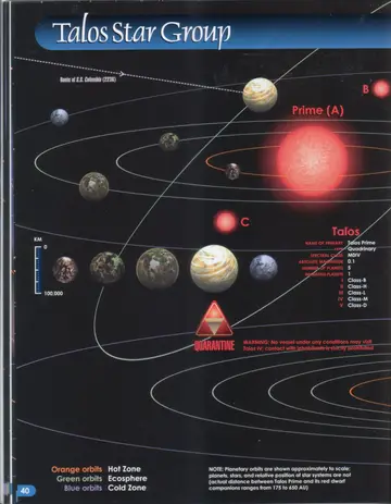
System chart of the Talos Star Group showing Talos Prime (A) and its red dwarf companions (B, C), the five planets, the route of the S.S. Columbia (2236), comparative planet sizes, and the QUARANTINE warning.
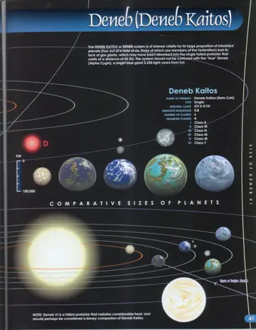
System chart of Deneb Kaitos showing the primary, its planets, the red dwarf companion (D), comparative planet sizes, the failed protostar Deneb VI, and the route of Redjac (Kesla).
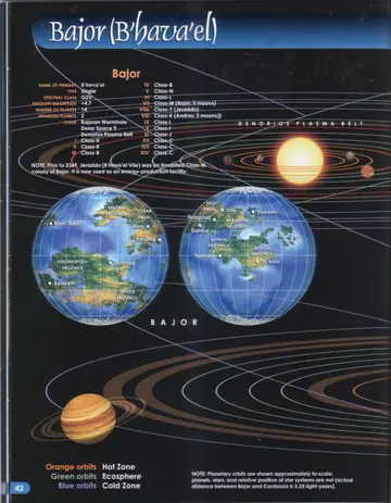
System chart of the B'hava'el system showing the Denorios Plasma Belt and the planet Bajor depicted as twin globes with its surface provinces labeled (Dahkur, Sahving, Hedrikspool, Kendra, and others).
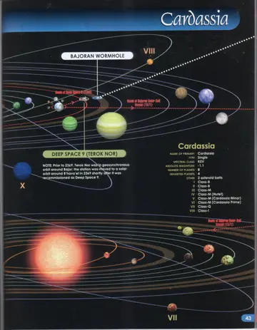
System chart of Cardassia showing the eight planets, the Bajoran Wormhole, Deep Space 9 (Terok Nor), and the routes of Deep Space 9 (2369) and the Bajoran Solar-Sail Vessel (1571).
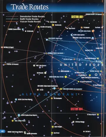
Trade Routes map (left page): Denobulan, Earth, and Vulcan trade routes across the Alpha Quadrant, centered on Sol (Earth) and Denobula Triaxa (Iota Bootis), with Sectors 001 and 004 marked.
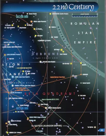
Trade Routes map (right page): 22nd-century routes extending into the Beta Quadrant toward Vulcan, the Romulan Star Empire and Neutral Zone, and Qo'noS (Klingon Empire), including the route of Enterprise NX-01 (2151) and the ancient Debrune Trade Route.
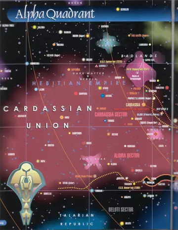
Map of the Cardassian Union (left page): the Cardassia and Algira sectors, the Badlands, Rolor and Amleth Nebulae, Deep Space 9, Bajor, and bordering Breen and Talarian Republic territory, with the losses of the U.S.S. Equinox (2373), U.S.S. Voyager (2371), and U.S.S. Denver (2368).
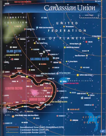
Map of the Cardassian Union (right page): the Bajor, Kalandra, Almatha, and Dorvan sectors bordering the Tzenkethi Coalition and United Federation of Planets, showing the Demilitarized Zone (established 2370) and the Cardassian Borders of 2339-69 and 2375.
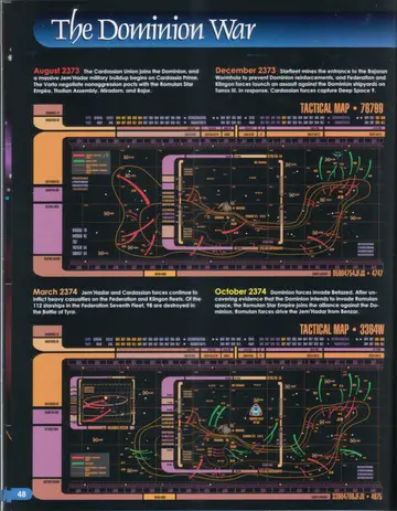
The Dominion War timeline (first page): tactical maps for August 2373, December 2373, March 2374, and October 2374.
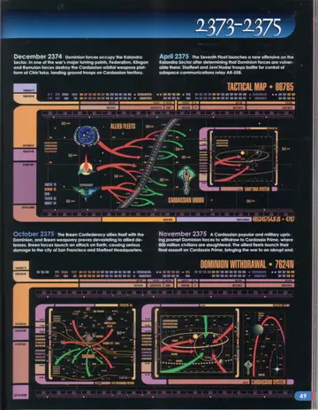
The Dominion War timeline (2373-2375, second page): tactical maps for December 2374, April 2375, October 2375, and the Dominion withdrawal of November 2375.
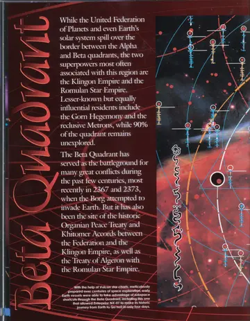
With the help of Vulcan star charts, meticulously prepared over centuries of space exploration, early Earth vessels were able to take advantage of subspace shortcuts through the Beta Quadrant, including the one that allowed Enterprise NX-01 to make its historic journey from Earth to Qo'noS in only four days.
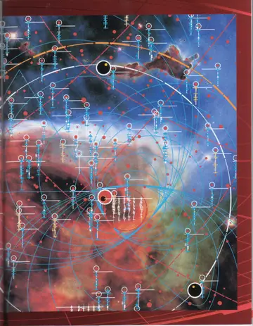
Full-page star map of the Beta Quadrant, showing densely plotted star systems against the surrounding nebulae.
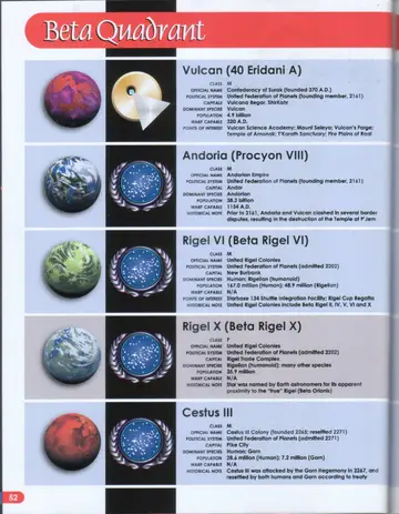
Planetary portraits and emblems for Vulcan, Andoria, Rigel VI, Rigel X, and Cestus III.
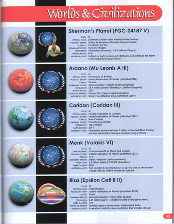
Worlds & Civilizations: planetary portraits and emblems for Sherman's Planet, Ardana, Coridan, Menk, and Risa.
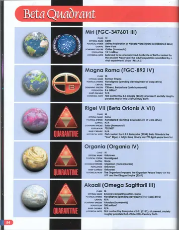
Planetary portraits and emblems for Miri, Magna Roma, Rigel VII (with QUARANTINE warning), Organia (with QUARANTINE warning), and Akaali (with QUARANTINE warning).
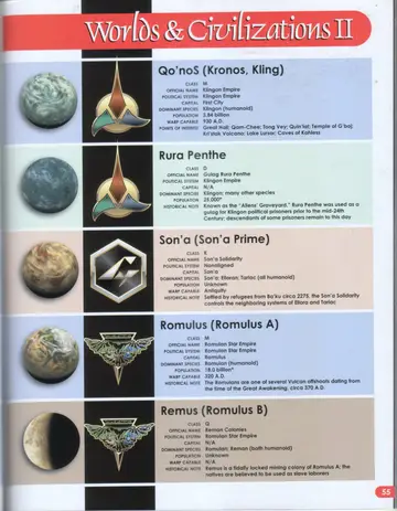
Worlds & Civilizations II: planetary portraits and emblems for Qo'noS, Rura Penthe, Son'a, Romulus, and Remus.
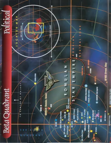
Political map of the Beta Quadrant (left page): the Romulan Star Empire and Romulan Neutral Zone, with a locator map and the direction toward the center of the galaxy, bordering the Alpha Quadrant.
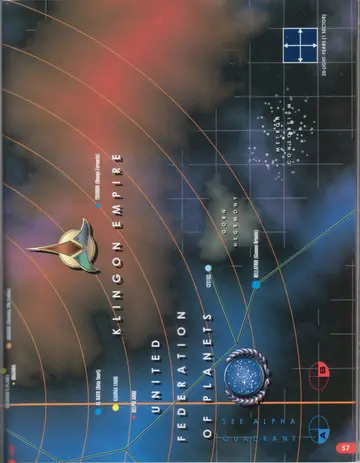
Political map of the Beta Quadrant (right page): the Klingon Empire and United Federation of Planets, with the Gorn Hegemony and Metron Consortium, marking Cestus and Bellatrix (Gamma Orionis), and a 20-light-year (one-sector) grid scale.
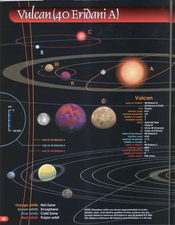
System chart of Vulcan (40 Eridani A) showing the primary (A) and its companion stars 40 Eridani B and C, the three planets including Vulcan (II) and T'Khut (III), comparative star sizes, and a km scale.
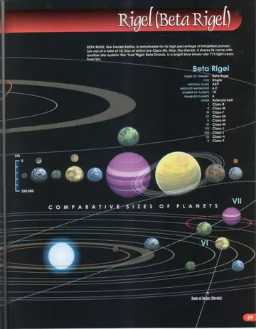
System chart of Rigel (Beta Rigel) showing the primary and its ten planets, comparative sizes of the planets, and the route of Redjac (Beratis).
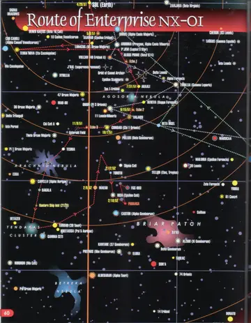
Route of Enterprise NX-01 map (left page): the early voyages of Enterprise NX-01 from Sol past Vulcan (40 Eridani A), Andoria, Akaali, and the Agosoria Nebula, with the Asteroid Field and surrounding star systems.
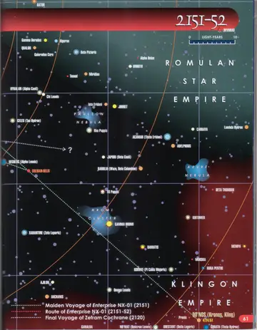
Route of Enterprise NX-01 map (right page): the route continuing toward the Romulan Star Empire and Qo'noS (Kronos, Kling), with a legend for the Maiden Voyage of Enterprise NX-01 (2151), the Route of Enterprise NX-01 (2151-52), and the Final Voyage of Zefram Cochrane (2120).
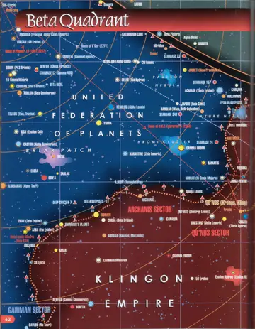
Map of the Klingon Empire (2151-52): the border region of the Romulan Star Empire, Klingon Empire, and United Federation of Planets, with the Paulson and Azure Nebulae, the Hromi Cluster, and worlds including Khitomer, Praxis, Qo'noS, and Rura Penthe.
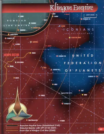
Map of the Klingon Empire showing the Mempa Sector, Pheben, and Starbase 24, with the Romulan Neutral Zone, the disputed border with the UFP (2152-2267), and the front line of the Klingon Civil War (2368).
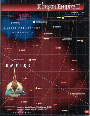
Map of the Klingon Empire (detail): the Mempa Sector and the Klingon-Federation border, marking the ancient Iconian sphere of influence (200,000 years ago), Narendra, K'T'inga, the route of V'Ger (2271), and several starbases, with a legend for the Romulan Neutral Zone (established 2160), the disputed border with the UFP (2152-2267), and the front line of the Klingon Civil War (2368).
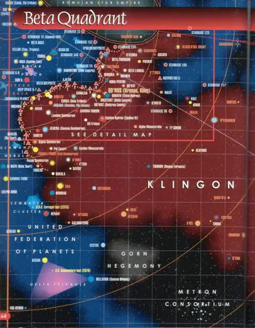
Overview map of the Beta Quadrant placing the Klingon Empire detail area in context, showing the Romulan Star Empire, United Federation of Planets, Gorn Hegemony, and Metron Consortium, the Briar Patch, the Delta Triangle, and the losses of the U.S.S. Bonaventure (2079) and the S.S. Farragut (2373), with a SEE DETAIL MAP callout.
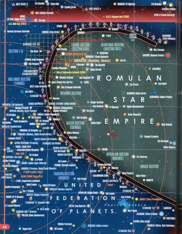
Map of the Romulan Star Empire (left page): the border with the United Federation of Planets, showing the Tango, Devron, Kaleb (Sierra), Tagran (Romeo), Bolarus (Tango), and Hyralan (Quebec) sectors, the site of the Enterprise loss (2364), and the Romulan Neutral Zone.
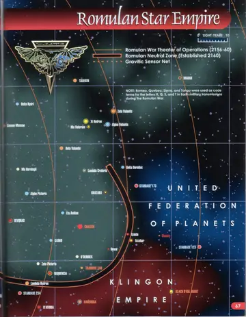
Map of the Romulan Star Empire (right page): the heart of the Empire bordering the United Federation of Planets and Klingon Empire, marking Romulus, Khazara, Norkan (Pi Hydrae), the Romulan War Theater of Operations (2156-60), the Romulan Neutral Zone (established 2160), and the Gravitic Sensor Net, with a note that Romeo, Quebec, Sierra, and Tango were used as code terms during the Romulan War.
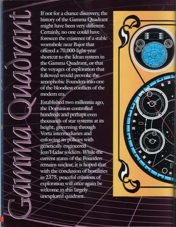
Decorative panel of Bajoran/Cardassian display readouts and a circular star chart, with the title Gamma Quadrant.
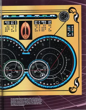
It is not certain if ancient Bajoran solar-sail vessels ever traveled to the far side of the galaxy through the Bajoran Wormhole, known to the Bajorans as the Celestial Temple. But if such a journey ever took place, this map found in the Bajoran Archives may be the first recorded star chart of the Gamma Quadrant.
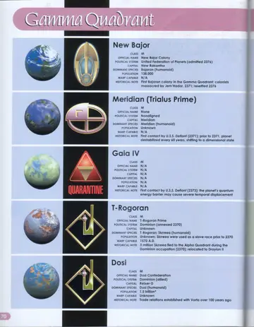
Planetary portraits and emblems for New Bajor, Meridian (Trialus Prime), Gaia IV (with QUARANTINE warning), T-Rogoran, and Dosi.
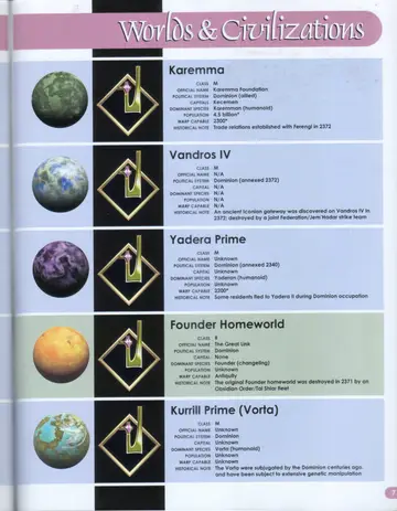
Worlds & Civilizations: planetary portraits and emblems for Karemma, Vandros IV, Yadera Prime, the Founder Homeworld, and Kurrill Prime (Vorta).
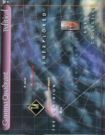
Political map of the Gamma Quadrant (left page): the Dominion and the Omarion Nebula (Founder Homeworld) near Idran, bordered by Unexplored space, the First Humanoids (4 billion years ago), and the Borg Collective, with Quasar M80, Quasar M39, and the route of the Quadros-1 Probe (2192-2369).
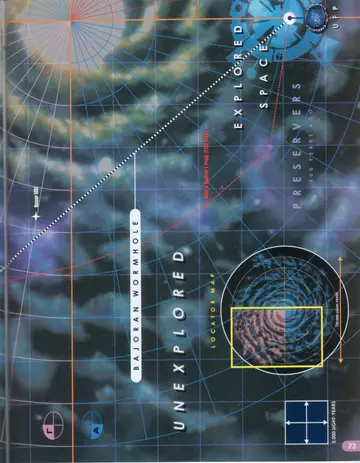
Political map of the Gamma Quadrant (right page): the Bajoran Wormhole leading to Unexplored space and Explored Space toward the UFP, the Preservers (4,830 years ago), and a locator map with grid scale.
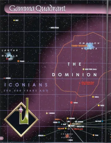
Star map of the Dominion (left page): the Omarion Nebula and Founder Homeworld, Kurrill Prime (Vorta), the Lantar Nebula, the Idran terminus of the Bajoran Wormhole with surrounding worlds (Karemma, Dosi, T-Rogoran, New Bajor, Parada, Wadi, Stakoron), the former Iconian region (200,000 years ago), the route of the Obsidian Order/Tal Shiar attack (2371), and the Chamra Vortex.
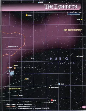
Star map of the Dominion (right page): the New Founder Homeworld in the former Hur'q region (1,000 years ago), Internment Camp 371, the Obatta Cluster and Jenkata Nebula, Trialus (Meridian), Yadera II, the loss of the U.S.S. Sarajevo (2370), and a legend for the Bajoran Wormhole, the Dominion Border (2275), and the Gamma Quadrant Bio-Survey (2369-75).
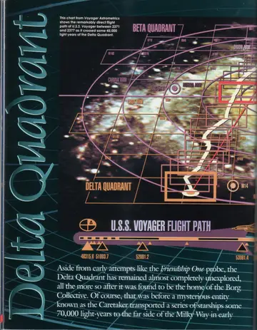
Title panel reading Delta Quadrant over a starfield, with the U.S.S. Voyager Flight Path (a chart from Voyager Astrometrics) showing the remarkably direct path of U.S.S. Voyager between 2371 and 2377 as it crossed some 45,000 light-years of the Delta Quadrant, marked with stardates 483158, 510037, 520812, 530614, and 530814.
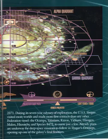
Continuation of the U.S.S. Voyager flight-path chart toward the Alpha and Gamma Quadrants, showing the Perseus Arm and Sagittarius Arm, the Bajoran Wormhole, the projected flight path, and a distance scale in light-years (x 10,000).
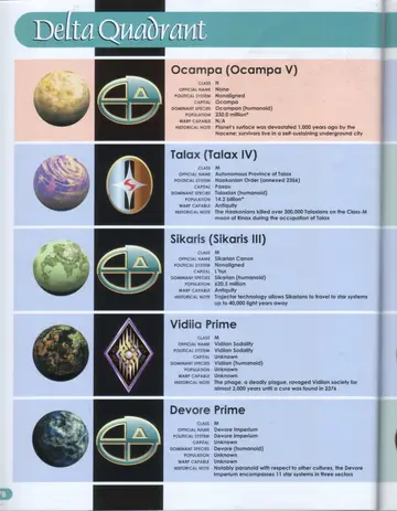
Delta Quadrant: planetary portraits and emblems for Ocampa (Ocampa V), Talax (Talax IV), Sikaris (Sikaris III), Vidiia Prime, and Devore Prime.
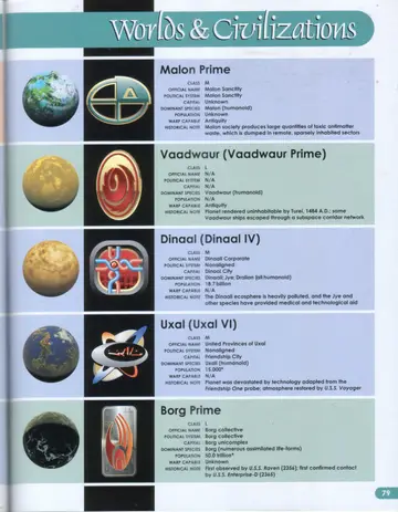
Worlds & Civilizations: planetary portraits and emblems for Malon Prime, Vaadwaur (Vaadwaur Prime), Dinaal (Dinaal IV), Uxal (Uxal VI), and Borg Prime.
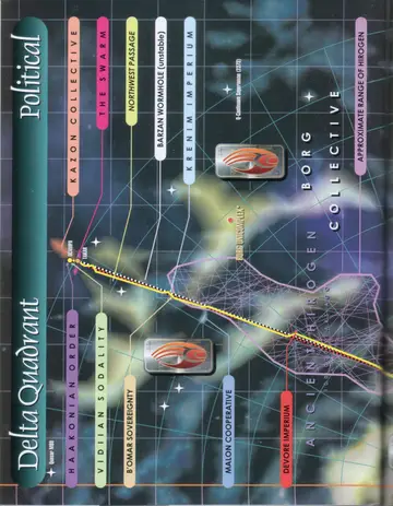
Political map of the Delta Quadrant (left page): the Haakonian Order, Vidiian Sodality, B'omar Sovereignty, Malon Cooperative, Devore Imperium, Kazon Collective, The Swarm, Northwest Passage, Barzan Wormhole (unstable), and Krenim Imperium, with U.S.S. Voyager's route and the Borg Collective overlying the Ancient Hirogen range and the approximate range of the Hirogen.
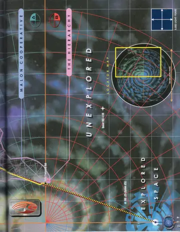
Political map of the Delta Quadrant (right page): the Malon Cooperative and The Hierarchy bordering Unexplored space and Explored Space, with a locator map (grid scale 5,000 light-years) of a swirling spatial feature.
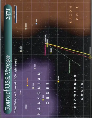
Route of U.S.S. Voyager, 2371: total distance traveled = 300 light-years. From Ocampa and the Caretaker Array through the Haakonian Order (Talax/Rinax, Mithren, Gree, Rekarr, Mylea, Jibalia, Trabal, Rectilia) toward the Kazon-Ogla, with the First Contact with Kazon and the route of the U.S.S. Equinox (2371).
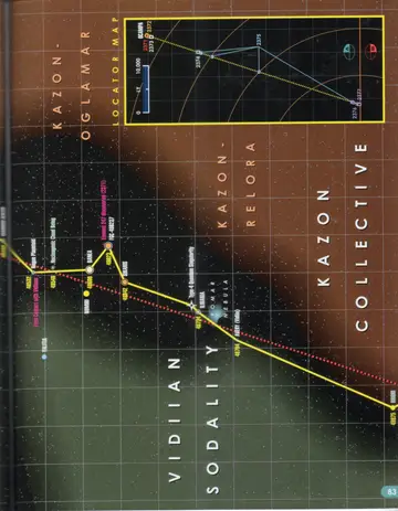
Route of U.S.S. Voyager, 2371 (continued): through Vidiian Sodality and Kazon-Oglamar, Kazon-Relora, and Kazon Collective space (Numiri, Banea, Sikaris, Ilidaria, Avery, Briori), with the First Contact with Vidiians, a Type-4 Quantum Singularity, the Komar Nebula, Element 247 discovered (2371), and a locator map of the route from 2371 to 2377.
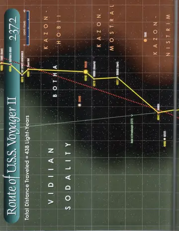
Route of U.S.S. Voyager II, 2372: total distance traveled = 438 light-years. Through the Vidiian Sodality, Botha, Kazon-Hobii, Kazon-Mostral, and Kazon-Nistrim regions (Tarok, Sky Spirits' Homeworld, Planet Hell, Cravic, Phalor, Mokra/Alsaurla, Sobras/Takret, Rakosa, Kotati, Trabe), with Suspiria's Array and the route of the Dreadnought (2372).
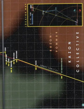
Route of U.S.S. Voyager II, 2372 (continued): through the Kazon-Pommar and Kazon Collective regions (Pihx/Tomin, Kolhari, Vidiian Colony, Draya/Crysata, Kohl Settlement) to New Earth, marked U.S.S. Voyager Returns to New Earth (70 light-years), with a locator map of the route from 2371 to 2377.
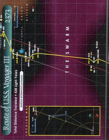
Route of U.S.S. Voyager III, 2373: total distance traveled = 438 light-years. Crossing The Swarm and a Class-M Nebula through Kazon-Nistrim space toward the Barzan Wormhole (unstable), with a locator map of the route from 2371 to 2377.
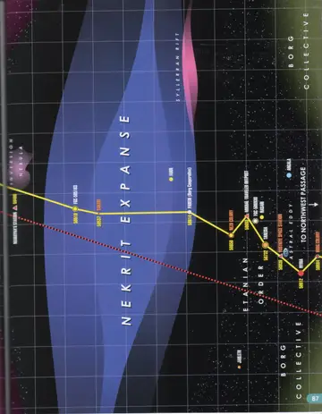
Route of U.S.S. Voyager III, 2373 (continued): across the Nekrit Expanse (Mahayna's Station, FGC-505183, Sakari, Parein/Borg Cooperative, Farn) through the Etanian Order (Nezu Colony, Mikhal Traveler Outpost, FGC-509930, Nasari, Taresia, Vostigye Space Station, Astral Eddy, Nyria, Argala, Borg Colony) toward the Northwest Passage, bordered by the Inversion Nebula, the Syllerran Rift, and the Borg Collective.
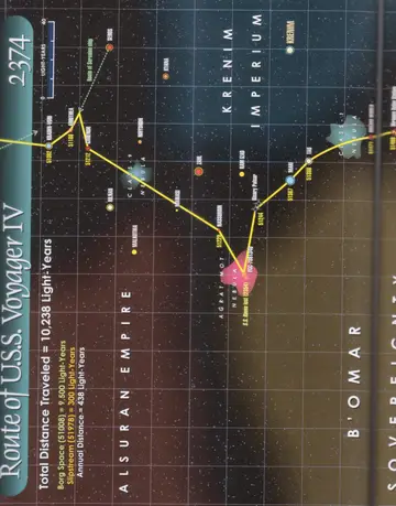
Route of U.S.S. Voyager IV, 2374: total distance traveled = 10,238 light-years (Borg Space 9,500 ly; Slipstream 300 ly; Annual Distance 438 ly). Through the Alsuran Empire, Krenim Imperium, and B'omar Sovereignty (Kradin-Vori, Arrithea, Garenor, Seros, Kyana, Rilnar, Malkothia, Nawasi, Nassordin, Krenim, Zahl, Ram Izad, Mari, Tau), with a Binary Pulsar, the Agrat-Mot Nebula, the S.S. Raven lost (2354), and the route of a Serosian ship.
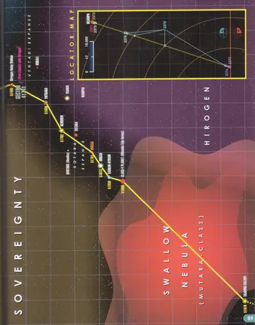
Route of U.S.S. Voyager IV, 2374 (continued): through B'omar Sovereignty and Hirogen space (Hirogen Relay Station, Sector 41741, Enthara, Trakia, Kobali, Kendren, Entaba, Omega, Benthos/Bentha, Mikah, Vaskan-Kyrian, Class-Y Planet/Mimetic Life-forms, Trading Colony) across the Vyntadi Expanse, Kotaba Expanse, and Swallow Nebula (Mutara-class), with the First Contact with Hirogen and a locator map of the route from 2371 to 2377.
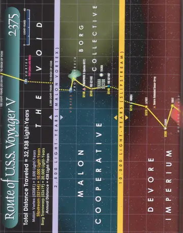
Route of U.S.S. Voyager V, 2375: total distance traveled = 32,938 light-years (Malon Vortex 2,500 ly; Slipstream 10,000 ly; Borg Transwarp 20,000 ly; Annual Distance 438 ly). Across The Void to the Malon Vortex, then through the Malon Cooperative, Borg Collective, and Devore Imperium (Terrasphere 8/Species 8472, Tekara, Monea, Layoti, Tekara, Torat), with the First Contact with Malon, a protonebula, the Tekara Sector, and a Devore Automated Sensor Array.
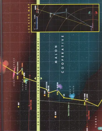
Route of U.S.S. Voyager V, 2375 (continued): a 20,000-light-year Borg Transwarp jump through the Malon Cooperative and Turei space (Noss, Bioplasmic Lifeform, Sinkhole, Matori, Rivos, Think Tank, Kadii, Salinia, Hazari, Class-Y Cluster, Subspace Sandbar) with the route of the Varro Ship, the route of the U.S.S. Equinox, the route of the Warhead, and a locator map of the route from 2371 to 2377.
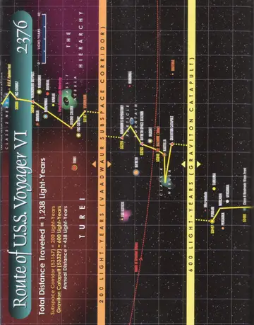
Route of U.S.S. Voyager VI, 2376: total distance traveled = 1,238 light-years (Subspace Corridor 200 ly; Graviton Catapult 600 ly; Annual Distance 438 ly). Through Turei space and The Hierarchy via Vaadwaur Subspace Corridors and a Graviton Catapult, with assorted star systems, nebulae, and spatial features along the route.
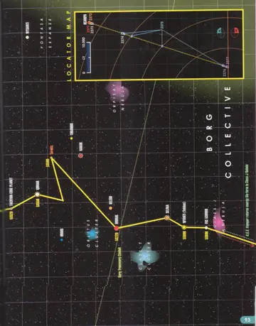
Route of U.S.S. Voyager VI, 2376 (continued): through the Borg Collective and the Yontasa Expanse (Tachyon-Core Planet, Qomar, Hudos, Tarakis, Tiranius, Nakan, Kelsid, Brunal, Selnia, Wysanti/Teirsus, FGC-538360), past the Orpisay Nebula, Class-T Clusters, and a Class-J Nebula, with the Borg Transwarp Conduit and U.S.S. Voyager returns energy life-form to Class-J Nebula, and a locator map of the route from 2371 to 2377.
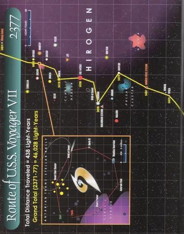
Route of U.S.S. Voyager VII, 2377: total distance traveled = 438 light-years; Grand Total (2371-77) = 46,028 light-years. Through Hirogen space and a Class-T Nebula (Antaria, Imhotep, Velos, Chessu, Jye, Aksani, Dralia, Dinaal, Terrellia, Selek, Cunaehm, Maldorian Station, Maldor, Annari, Krenim, Kraylor, Annwari, Pulsar Cluster, Hirogen Space Station, Bewkar, Nygea), with an inset Antarian Trans-Stellar Rally course (Start to Finish past the Orbit of Comet, Davta IV, Moebius Inversion, Asteroid Field, Binary Pulsar, Dwarf Star Cluster, and Class-J Nebula).
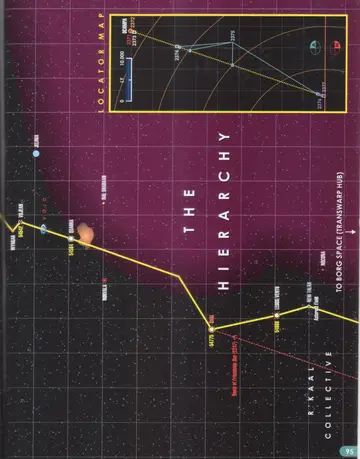
Route of U.S.S. Voyager VII, 2377 (continued): through R'Kaal Collective space and The Hierarchy (Jelinia, Voljean, Wyngari, Quarra, Nal Shadaan, Norvala, Uxal, Ledos/Ventu, New Talax, Nocona) past a Void, an Asteroid Field, and the route of the Friendship One drone (2247), toward Borg Space (Transwarp Hub), with a locator map of the route from 2371 to 2377.
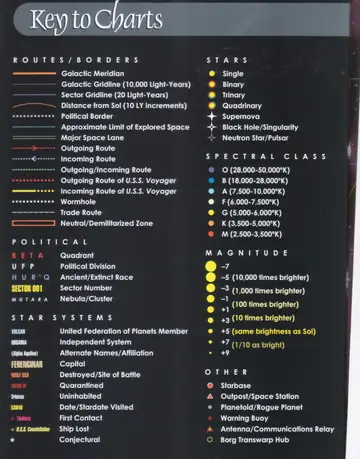
Key to Charts: the complete legend of symbols used in the atlas, organized into Routes/Borders, Stars, Spectral Class, Magnitude, Political, Star Systems, and Other.
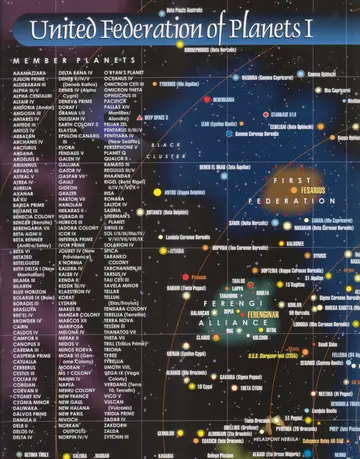
United Federation of Planets I: a star map of the core of Federation space, with the alphabetical list of UFP member planets, bordered by the First Federation, the Ferengi Alliance, and the Black Cluster.
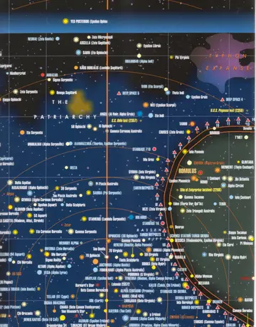
United Federation of Planets I (continued): a star map of the spinward border region, showing The Patriarchy, the Typhon Expanse, the Mutara Nebula, the Site of the Enterprise Incident (2268), and the loss of the U.S.S. Pegasus (2358), extending toward Romulus.
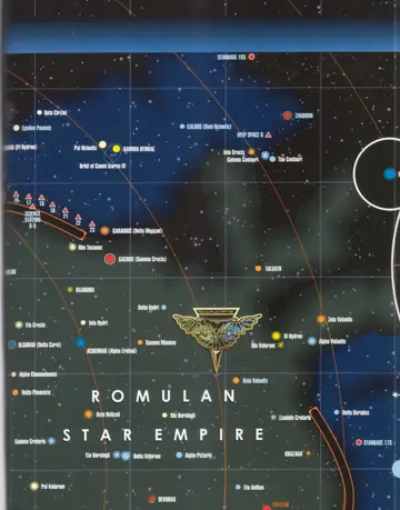
United Federation of Planets I (continued): a star map of the Romulan Star Empire border, with the Romulan emblem, the Azure Nebula region, Acamar (Theta Eridani), Achernar (Alpha Eridani), Khazara, and starbases including Starbase 173 and Starbase 185.
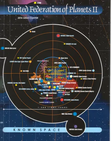
United Federation of Planets II: a radial chart titled Known Space, 1,500 light-years across, with the central inset divided into Chart 1, Chart 2, Chart 3, and Chart 4, surrounded by named star systems including Sheliak, Rigel (Beta Orionis), Betelgeuse (Alpha Orionis), Tholia, the Pleiades Cluster, the Mutara Nebula, and the Helical Nebula.
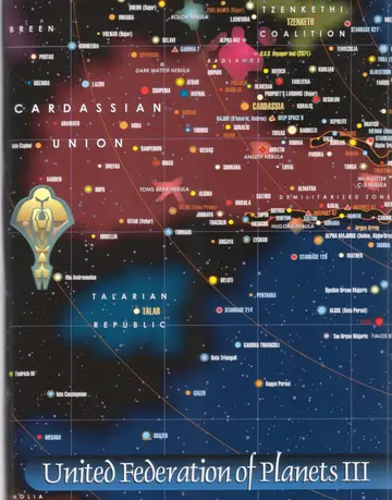
United Federation of Planets III: a star map of the antispinward border, showing the Cardassian Union, the Talarian Republic, the Tzenkethi Coalition, the Breen, the Demilitarized Zone, Cardassia, Bajor, the Dark Matter Nebula, and the loss of the U.S.S. Voyager (2371).
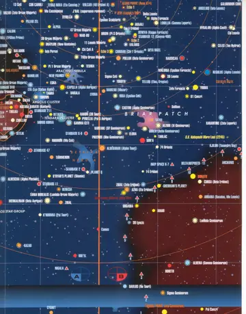
United Federation of Planets chart (continued): a star map of the core systems including the Briar Patch, Regulus (Alpha Leonis), Capella (Alpha Aurigae), the Tendara Cluster, the Argus Star Group, and locator markers A and B linking to the detailed inset charts.
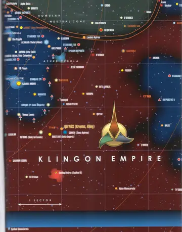
United Federation of Planets chart (continued): a star map of the Klingon Empire and the Romulan Neutral Zone, with the Klingon emblem, Qo'noS (Kronos, Kling), Praxis, Khitomer, Narendra, Rura Penthe, the Azure Nebula, and a one-sector scale bar.
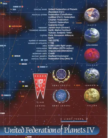
United Federation of Planets IV: the official profile of the Federation, with planetary portraits of the founding worlds Earth, Alpha Centauri, Vulcan, Andoria, and Tellar, the UFP flag (2268), the Federation seals of 2271 and 2364, and a star-map background.
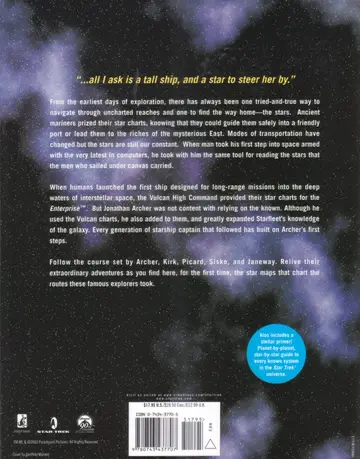
Chapter opener: "...all I ask is a tall ship, and a star to steer her by." The introductory text on a starfield background.
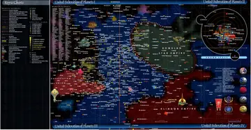
United Federation of Planets I-IV: the four-panel master fold-out map of Federation space, presented with the Key to Charts legend at left and showing the Cardassian Union, the Romulan Star Empire, the Klingon Empire, and the bordering Brown Space and Federation member systems; includes the official United Federation of Planets profile.
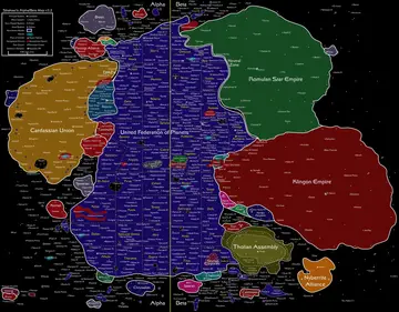
Shakaar's Alpha/Beta Map v3.2: a political map spanning the Alpha and Beta Quadrants, with the United Federation of Planets at center surrounded by the Cardassian Union, the Ferengi Alliance, the Breen, the Romulan Star Empire with its Neutral Zone, the Klingon Empire, the Tholian Assembly, and the Nyberrite Alliance, accompanied by a dense alphabetical index of star systems and a symbol legend.
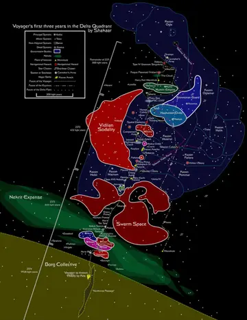
Voyager's first three years in the Delta Quadrant, by Shakaar: a route map marking Voyager's path from 2371 onward through the Vidiian Sodality, the Nistrim and other Kazon sects, the Haakonian Order, the Numiri/Numin Empire, Swarm Space, the Nekrit Expanse, and toward the Borg Collective, with Kes throwing the ship 9500 light-years (2374) and a legend of system types, hazards, and routes (Voyager, Equinox, Delta Flyer).
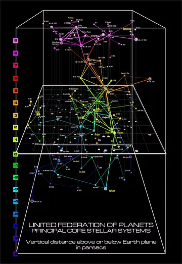
United Federation of Planets — Principal Core Stellar Systems (side view, left half): a 3D box plot showing vertical distance above or below the Earth plane in parsecs (scale +9 to roughly -7), with major systems such as Sol, Alpha Centauri, Sirius, Procyon, Andor, Tellar, Vulcan, Tau Ceti, Arcturus, and Denebola connected by colored sight lines.
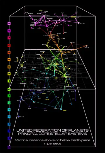
United Federation of Planets — Principal Core Stellar Systems (side view, right half): continuation of the 3D side-view chart, showing the same parsec scale and connecting lines extending across the Earth plane toward Denebola, Beta Hydri, and the outer systems.
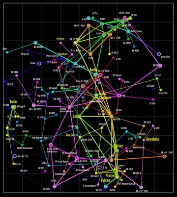
United Federation of Planets core stellar systems (top view): a grid map of the core systems seen from above the galactic plane, with Sol, Alpha Centauri, Andor, Sirius, Procyon, Vulcan, Tellar, Tau Ceti, Arcturus, Fomalhaut, Denebola, and Beta Hydri connected by colored sight lines.
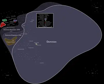
The Dominion: a map of Dominion-controlled space in the Gamma Quadrant centered on Cardassia, showing the Dominion Expansion borders of 2369 and 2370, the T-Rogoran Empire, the Karemma worlds, the Bajoran Wormhole, the Omarian Nebula, and a legend of system types and features (1,000-light-year scale).
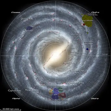
Milky Way Galaxy galactic map: a photographic top view of the spiral galaxy with its arms labeled (Dinkiri, Norma, Scutum-Crux, Sagittarius-Carina, Orion, Perseus, and Cygnus Arms), the four quadrants marked at the edges, and the locations of major powers including the United Federation of Planets, Cardassian Union, Romulan Star Empire, and Klingon Empire (Alpha/Beta), the Dominion (Gamma), and the Borg Collective, Kazon sects, Vidiian Sodality, Devore Imperium, Malon, Hierarchy, Krenim Imperium, and Voth (Delta); 20,000-light-year scale.
An unhandled error has occurred. Reload 🗙

Rejoining the server...

Rejoin failed... trying again in seconds.

Failed to rejoin.
Please retry or reload the page.

The session has been paused by the server.

Failed to resume the session.
Please retry or reload the page.